Florida Prepares for Severe Blow from Hurricane Ian
Hurricane Ian stretches nearly 500 miles from east to west—double the width of the Florida peninsula it now endangers.
“This storm is so large that it’s going to affect people from Tampa down to Naples,” said Rick Davis, a meteorologist for the National Weather Service, to the Bradenton Herald. “Even if the eye itself doesn’t pass you, the wind field is huge. The storm surge is big. It’s going to impact a large area.”
Catasrophic wind.
— National Weather Service (@NWS) September 28, 2022
Catastrophic surge.
Catastrophic rainfall and flooding.
These are the last hours to prepare or escape before conditions worsen and #Ian arrives in south and central Florida. https://t.co/25KlHVAM5K
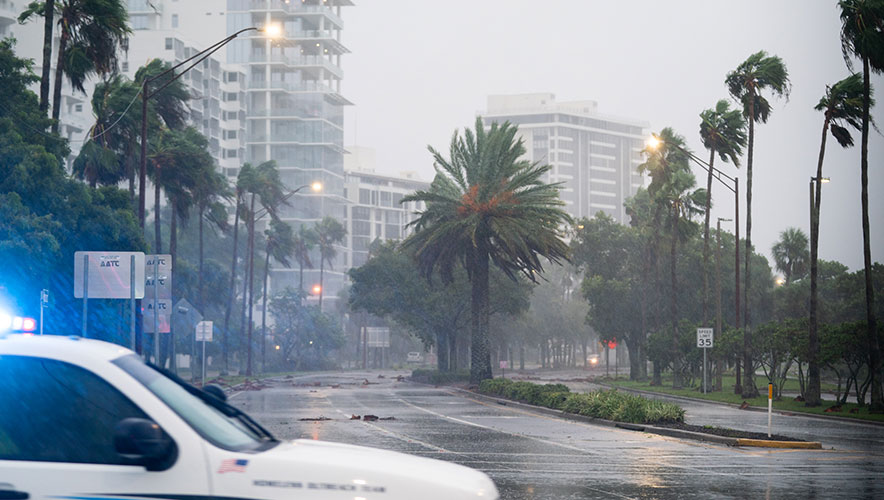
The size of this storm is what will make it so dangerous, Davis added—the eye of the hurricane is 40 miles wide, and hurricane-force winds will extend another 100 miles out, widening the field of potential damage significantly compared to many past hurricanes.
Hurricanes can change direction and impact quite quickly, so here’s what we currently know, and Security Management will update this page as conditions change.
The State of the Storm
As of early 28 September, Hurricane Ian was just 2 miles per hour of sustained winds short of being classified as a Category 5 storm—the most severe category on the Saffir-Simpson Hurricane Wind Scale. Its current maximum sustained wind speeds are nearly 155 miles per hour.
Ahead of Hurricane Ian making landfall, the storm front spurred tornadoes to touch down in southern Florida on 27 September, uprooting trees and damaging property.
Meanwhile, state officials are offering dire warnings about the storm’s potential impact. Torrential downpours could result in up to two feet or more of rainfall across Florida, the National Hurricane Center said.
“Widespread, life-threatening catastrophic flash, urban, and river flooding is expected across central Florida,” according to the National Hurricane Center. “Widespread considerable flash, urban, and river flooding is expected across portions of southern Florida through Wednesday, and northeast Florida, southeastern Georgia, and coastal South Carolina later this week through the weekend.”
Floridians should also expect a catastrophic storm surge inundation of 12 to 18 feet above ground level, depending on their location.
The storm is expected to make landfall along Florida’s western coastline this afternoon and evening.
Florida wasn’t the only area in Hurricane Ian’s path. It swept over Cuba earlier this week and knocked out power across the entire island—affecting 11 million people, The Washington Post reported. At least two people died in the storm. The west side of Cuba suffered more damage, according to the Electrical Union of Cuba. The utility’s goal is to restore power in the grid’s three sections and then reconnect them to the national electric system.
After hitting Cuba, the storm strengthened as it moved over the warm waters of the Gulf of Mexico, getting 67 percent stronger in less than 22 hours, the Associated Press reported. Sudden changes in strength like this cause significant problems for forecasters and emergency planners trying to keep people informed and safe. Climate change—and the related warmer ocean waters—makes these rapidly supercharged storms more frequent and more damaging, the AP noted. Research shows that these types of hurricanes hold more moisture and move more slowly, which can result in a storm dumping huge amounts of rain in a single area, like 2017’s Hurricane Harvey, which flooded areas of Louisiana and Texas.
Evacuations and Preparations Ramp Up
Thousands of Florida residents evacuated low-lying coastal communities and attempted to shore up their homes and businesses against the incoming storm. Evacuation orders along the Gulf Coast cover more than 2 million Floridians, the Post reported.
People seeking to entirely escape the region as the hurricane neared found themselves grounded—airlines cancelled more than 2,000 flights on 27 and 28 September, and some airports in Florida halted operations entirely, according to the AP. Major attractions in Florida, including Walt Disney World Resort and theme parks, announced closures today and Thursday as the storm approaches.
The Florida Department of Health has initiated a patient movement mission to evacuate 15 hospitals in areas of anticipated landfall. Tolls on major roadways in central Florida were suspended to facilitate easier movement through the state.
Changes to the U.S. state’s population in recent years may make storm preparation even more complicated. Florida has added nearly 3 million residents since 2010, and three of the state’s fastest growing metropolitan areas—Tampa, Fort Myers, and Sarasota—are in the predicted path of the storm. According to NPR:
The population boom in hurricane-prone Florida is an example of the "expanding bullseye effect," said Stephen Strader, a professor at Villanova University who studies how human environments are vulnerable to natural disasters.
Imagine an archer taking aim at a target, he explained. If the bullseye is very small, the odds of the archer hitting it are low. But as the target grows, the archer's odds improve.
"Instead of an arrow, we have hazard events like hurricanes and tornadoes. Instead of having targets, we are the targets – our cities, our developed areas. And nowhere is that more readily seen than along our coastlines," Strader said.
The influx of new residents and hurricane first-timers requires additional resources for education, awareness, and communication from state officials.
Meanwhile, U.S. President Joe Biden has approved Florida Governor Ron DeSantis’s request for a federal emergency declaration ahead of the storm. Members of the National Guard and reservist personnel are at the ready to be sent to the hardest hit regions, and generators for critical infrastructure applications are being pre-staged, according to Local 10 News. Additional supplies—including 3.7 million meals, 3.5 million liters of water, and 128,000 gallons of fuel—were also moved to Florida.